Play store

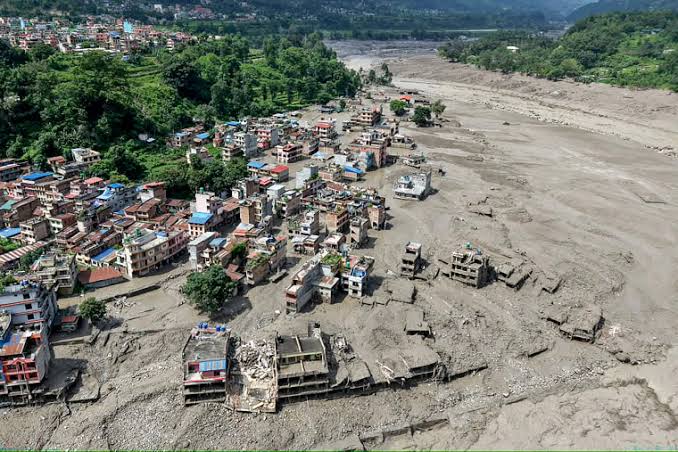
Nepal is once again confronting a devastating natural disaster. Last Wednesday morning, a massive surge of water swept through the Bhote Koshi River in Rasuwa district, near the Tibet-China border, before moving downstream and joining the Trishuli River. Landslides and flash floods have reportedly killed at least 472 people in Nepal and Tibet, while nearly 1,500 remain missing, including more than 800 foreign tourists.
The disaster is particularly alarming because it occurred along a river corridor that experienced another major flood just 13 months ago.
Nepal’s vulnerability is not the result of a single natural hazard. Instead, several forces are converging: rising temperatures and glacier melt, unstable mountain slopes, active tectonic movement, sudden river blockages, limited early-warning systems and infrastructure built in high-risk areas.
What Triggered the Flood?
Scientists and officials have proposed slightly different explanations for what happened last Wednesday, but they largely agree on the basic sequence.
Nepal’s Foreign Minister Shishir Khanal told parliament that a tremor at around 8:37 a.m. triggered a massive landslide, blocking the river and creating a natural dam. As water accumulated behind the blockage, pressure eventually caused it to collapse, sending a destructive wall of water downstream.
The U.S. Geological Survey initially recorded what appeared to be a magnitude 4.4 earthquake roughly 47 kilometers north of Gosainkunda in Tibet. It later clarified that the signal was generated by a massive landslide rather than a conventional earthquake.
Scientists at the International Centre for Integrated Mountain Development (ICIMOD) have pointed to another possibility involving the Lende Khola, a tributary of the Bhote Koshi. A huge mass of ice and rock may have fallen into the river, temporarily blocking its flow. The accumulated water then broke through the obstruction, producing the flash flood.
Glacier expert Rijan Bhakta Kayastha of Kathmandu University has offered a similar assessment after discussions with scientists from Nepal and China. He noted that the Lende Khola experienced a similar blockage and flood last year.
Satellite imagery from August 24 is now being examined to determine what happened in the glacier region immediately before and after the disaster.
Whatever the precise trigger, the underlying mechanism appears clear: a mountain river was suddenly blocked, enormous quantities of water accumulated upstream, and the natural barrier eventually failed.
The consequences were catastrophic.
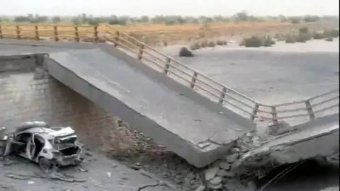
At the Rasuwagadhi crossing on the China-Nepal border, the main bridge leading to the border gate was swept away. The region has now become the center of one of the worst scenes of destruction.
The Himalayas’ Growing Glacier Threat
Glacial lake outburst floods are not a new phenomenon in the Himalayas. But climate change is increasing the potential for such events.
As temperatures rise, Himalayan glaciers are losing ice at an accelerating rate. Meltwater can accumulate behind fragile natural barriers, creating glacial lakes that may suddenly burst.
A recent ICIMOD study found that the rate of glacier ice loss across the Hindu Kush Himalayas has nearly doubled since 2000. Millions of people live downstream from these glaciers and river systems, leaving them increasingly exposed to sudden floods.
A 2020 UNDP survey identified 3,624 glacial lakes across Nepal’s Koshi, Gandaki and Karnali river basins. Forty-seven were classified as highly dangerous—25 in Tibet, 21 in Nepal and one in India.
But identifying dangerous lakes is not enough.
Glacial lakes can grow rapidly as glaciers retreat, and new lakes can appear in places where none existed before. The lake responsible for the devastating 2025 flood, for example, was reportedly not on scientists’ risk lists before the disaster.
That makes monitoring the Himalayas a race against time.
A History of Catastrophic Floods
Nepal’s current crisis also fits into a much longer history.
In July 1981, a glacial lake in Tibet’s Zhangzangbo Valley suddenly burst, killing more than 200 people, destroying the Friendship Bridge and severely damaging the Sun Koshi hydropower plant.
Major floods linked to similar processes were also recorded in 1964 and 1983.
Nepal itself has experienced at least 24 major glacial lake outburst floods, according to the World Bank. Fourteen originated within Nepal and another 10 in Tibet.
Historical evidence suggests that such disasters have occurred for centuries. Around 450 years ago, a natural dam in the Seti Khola basin near Machhapuchhre collapsed, sending an enormous volume of mud and rock into the Pokhara Valley.
The scale of destruction was immense, with parts of the valley reportedly buried under tens of meters of debris.
Why Isn’t Nepal Getting Enough Warning?
The recurring disasters have raised another critical question: why are communities not receiving sufficient advance warning?
The answer is partly political and technological.
After last year’s disaster, Nepal’s Department of Hydrology and Meteorology acknowledged that the country lacked an effective bilateral mechanism for receiving glacier-related information from Tibet.
China does provide occasional warnings about heavy rainfall, but glacial lake outburst floods can occur without significant rainfall. A lake can burst because of a landslide, rockfall, ice collapse or failure of its natural dam.
During last year’s flood, Nepali authorities reportedly received no warning from a scientific forecasting system. They learned about the approaching flood only about an hour before it entered Nepal, after border security personnel raised the alarm.
Nepal subsequently agreed to work with China to strengthen early-warning systems. The UN’s Green Climate Fund also approved approximately $36 million in funding in July 2025 to help address the region’s growing climate-related risks.
Yet an automated system capable of delivering immediate cross-border warnings has still not been fully established.
The latest disaster shows just how dangerous that gap can be.
Nepal’s Other Problem: It Sits on a Tectonic Fault Line
Climate change is only part of the story.
Nepal sits directly on the collision zone between the Indian and Eurasian tectonic plates. The Indian Plate continues to move northward at roughly 20–21 millimeters a year, pushing against the Eurasian Plate.
That collision began tens of millions of years ago and created the Himalayas.
The process has never stopped.
The Himalayas are still rising, while the enormous geological pressure continues to generate earthquakes, fractures and unstable mountain slopes.
The 2015 earthquake demonstrated the scale of Nepal’s vulnerability. It destabilized countless slopes across the country, leaving large quantities of rock and soil vulnerable to future landslides.
As a result, a major earthquake is not always necessary to trigger a disaster. A landslide, rockfall or even a relatively small seismic disturbance can destabilize an already fragile slope.
Last Wednesday’s event may be another example of this dangerous interaction between geology and water.
When Development Adds to the Risk
Natural hazards become disasters when people and infrastructure are placed directly in their path.
This is another growing concern in Nepal.
A 2024 study found that the risks posed by glacial lake outburst floods were not adequately considered during the development of the China-Nepal trade corridor. Roads, bridges, customs facilities and other infrastructure have been built close to rivers and floodplains.
Researchers from the Chinese Academy of Sciences and their colleagues have warned that a major glacial lake outburst flood could affect around 103 kilometers of the China-Nepal highway, 103 bridges, two major land ports and more than 3,300 structures in China and Nepal.
Recent events have already demonstrated the vulnerability.
The customs facility at Timure, near the Rasuwagadhi border crossing, has reportedly been destroyed twice within the past 13 months.
The Himalayas Are Beautiful—But Unforgiving
Nepal’s latest catastrophe cannot be explained by climate change alone, nor by earthquakes, landslides or poor infrastructure in isolation.
The country is facing the combined effects of a warming climate, rapidly changing glaciers, unstable mountain terrain, active tectonic forces, vulnerable river systems and inadequate cross-border warning mechanisms.
The Himalayas may appear permanent and immovable. Geologically, however, they are anything but static.
The mountains are still rising. Glaciers are shrinking. New lakes are forming. Slopes are becoming increasingly unstable. And communities, roads and economic infrastructure continue to expand into areas exposed to these hazards.
For Nepal, the challenge is no longer simply predicting the next disaster.
It is recognizing that the risks are changing faster than the systems designed to manage them.
The Himalayas are among the world’s most spectacular landscapes. But beneath that beauty lies a constantly shifting geological and climatic system—and Nepal sits directly in its path. Source NDTV.