


 Play store

When astronaut John Glenn orbited Earth in 1962, he remarked on a striking green valley northwest of El Paso, Texas, standing in sharp contrast to the surrounding dry landscape.
The greenery was largely made possible by a network of human-made lakes along the Rio Grande, which supplied water for agriculture in the arid region. Irrigation has supported crops including alfalfa, cotton, onions, pecans and the area’s famous Hatch green chiles.
More than six decades later, however, prolonged drought and unusually dry conditions across the Rio Grande basin are putting that agricultural lifeline under increasing pressure.
The situation worsened in 2026 after the river’s headwaters in the southern Rocky Mountains experienced the earliest snowmelt on record. The combination of persistent drought and reduced snowmelt has sharply diminished water supplies downstream.
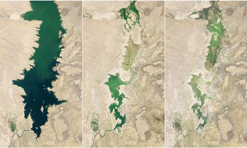
Elephant Butte Reservoir, New Mexico’s largest reservoir, fell to just 1.4 percent of its capacity, its lowest level since 1971.
A satellite image captured on July 27, 2026, showed the reservoir at this extremely low level. By comparison, the reservoir was nearly full on June 2, 1994, while water levels remained relatively high through much of the period from 1985 to 2000.
During another severe drought, the reservoir reached an annual low of 2.9 percent of capacity on July 8, 2013.
The dramatic decline in water levels in 2026 exposed debris that had been submerged along the shoreline and left sediment covering boat ramps at Elephant Butte Lake State Park.
The reservoir, however, appears to have reached its lowest level for the year in late July. State officials said agricultural water releases ended after July 28, allowing the reservoir to slowly begin recovering.
The crisis has also intensified concerns about the long-term availability of water along the Rio Grande. Communities, farmers and other water users in New Mexico and Texas rely on both surface water and groundwater across the valley.
With supplies becoming increasingly limited, authorities face difficult decisions over how water should be stored, allocated and shared among competing users.
NASA-backed projects are helping officials better understand and monitor the shrinking water supply.
Several initiatives supported by NASA’s Western Water Action Office use satellite observations and analytical tools to provide more detailed information on water availability and help improve resource allocation.
One project developed a near-real-time model that combines NASA satellite measurements of factors such as soil moisture and evapotranspiration. The system supplements existing water-allocation methods used by the Elephant Butte Irrigation District.
Another project combines satellite measurements of water-surface heights with observations collected by drones and ground-based instruments.
Researchers have used these combined observations to investigate how groundwater pumping affects the flow of the Rio Grande. The findings could provide water officials with valuable information for managing water rights and balancing demands on the river.
The sharp fall in Elephant Butte Reservoir illustrates how prolonged drought and changing snowmelt patterns can threaten one of the most important water sources for agriculture and communities in the Rio Grande Valley.