Play store

Nepal’s long-running and sensitive border dispute with India is rooted in the 1816 Treaty of Sugauli. But Kathmandu now finds itself in an uncomfortable position after the government admitted that it cannot confirm whether the original treaty is in its possession.
The revelation was made in Nepal’s Parliament after a government-backed search failed to locate the original document in the country’s National Archives, ministries and museums.
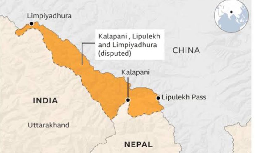
The treaty is central to Nepal’s territorial claims over Limpiyadhura, Kalapani and Lipulekh, areas that have remained disputed between Nepal and India.
Speaking in the House of Representatives, Foreign Minister Shishir Khanal said the government had no definitive information confirming that the original treaty was in its custody.
“We do not have specific information about whether the official treaty is with us,” the minister said, according to The Kathmandu Post.
He said records of several treaties were available at the National Archives, but it could not be confirmed whether they were the original documents.
The government has copies of the 1816 Treaty of Sugauli and the 1950 India-Nepal Treaty of Peace and Friendship, but the original Sugauli document is missing, the minister said.
Treaty at centre of border dispute
The dispute largely centres on Article 5 of the Sugauli Treaty, under which Nepal relinquished claims to territory west of the Kali, or Mahakali, River, effectively establishing the river as part of Nepal’s western boundary.
However, the two countries have long disagreed over the precise source of the Kali River.
Nepal maintains that the river originates at Limpiyadhura. Based on that interpretation, Limpiyadhura, Kalapani and Lipulekh lie east of the river and therefore belong to Nepal.
India, however, maintains that the Kali River originates from a stream below the Lipulekh area. It has cited historical administrative and revenue records to argue that Kalapani was historically administered as part of Pithoragarh district in the former United Provinces, now Uttarakhand.
According to The Kathmandu Post, the original treaty did not explicitly identify Limpiyadhura as the source of the Kali River, while it also remains unclear whether a boundary map was attached to the original agreement.
Dispute intensified in 2020
The border dispute escalated sharply in 2020 after India inaugurated an 80-kilometre road linking the Lipulekh area with Uttarakhand for the Kailash Mansarovar pilgrimage.
Nepal strongly protested the move. Then-prime minister KP Sharma Oli turned the dispute into a major nationalist issue, and his government issued a new political map incorporating Limpiyadhura, Lipulekh and Kalapani into Nepal.
The map was subsequently endorsed through a constitutional amendment and incorporated into the country’s official national symbols.
More recently, Nepal Prime Minister Balendra Shah told Parliament that just as India had occupied Nepali land, Nepal had also occupied Indian land in various places.
The Foreign Ministry later clarified that his remarks referred to technical border encroachments and that Nepal’s position on the disputed territories remained unchanged.
Nepal has also recently objected to an agreement between India and China to resume trade through the Lipulekh Pass.
The disappearance of the original Sugauli Treaty could now add another complication to Kathmandu’s efforts to substantiate its historical and legal claims in negotiations with New Delhi, potentially raising questions over the documentary basis of Nepal’s position in the decades-old border dispute.